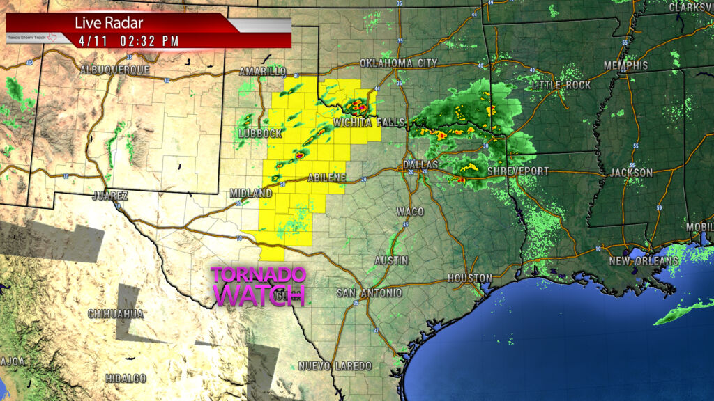
A TORNADO WATCH HAS BEEN ISSUED FOR PORTIONS OF WESTERN AND NORTHWEST TEXAS ALONG WITH PORTIONS OF SOUTHWEST OKLAHOMA. THIS WATCH IS IN EFFECT FROM 2:00 PM TO 10:00 PM.
URGENT – IMMEDIATE BROADCAST REQUESTED
Tornado Watch Number 100
NWS Storm Prediction Center Norman OK
200 PM CDT Sat Apr 11 2020
The NWS Storm Prediction Center has issued a
- Tornado Watch for portions of
Southwest Oklahoma
Western and northwest Texas - Effective this Saturday afternoon and evening from 200 PM until
1000 PM CDT. - Primary threats include…
A few tornadoes likely
Scattered large hail and isolated very large hail events to 3
inches in diameter likely
Scattered damaging wind gusts to 70 mph possible
SUMMARY…Scattered thunderstorms will gradually intensify along and
ahead of the dryline into the early evening. Some of these will
develop into supercells with the primary hazards being very large
hail and a few tornadoes.
The tornado watch area is approximately along and 70 statute miles
east and west of a line from 35 miles southwest of San Angelo TX to
30 miles northwest of Altus OK. For a complete depiction of the
watch see the associated watch outline update (WOUS64 KWNS WOU0).
PRECAUTIONARY/PREPAREDNESS ACTIONS…
REMEMBER…A Tornado Watch means conditions are favorable for
tornadoes and severe thunderstorms in and close to the watch
area. Persons in these areas should be on the lookout for
threatening weather conditions and listen for later statements
and possible warnings.
&&
AVIATION…Tornadoes and a few severe thunderstorms with hail
surface and aloft to 3 inches. Extreme turbulence and surface wind
gusts to 60 knots. A few cumulonimbi with maximum tops to 500. Mean
storm motion vector 25030.
WT 0100
PROBABILITY TABLE:
PROB OF 2 OR MORE TORNADOES : 60%
PROB OF 1 OR MORE STRONG /EF2-EF5/ TORNADOES : 20%
PROB OF 10 OR MORE SEVERE WIND EVENTS : 40%
PROB OF 1 OR MORE WIND EVENTS >= 65 KNOTS : 20%
PROB OF 10 OR MORE SEVERE HAIL EVENTS : 70%
PROB OF 1 OR MORE HAIL EVENTS >= 2 INCHES : 60%
PROB OF 6 OR MORE COMBINED SEVERE HAIL/WIND EVENTS : 90%
TORNADO WATCH 100 IS IN EFFECT UNTIL 1000 PM CDT FOR THE
FOLLOWING LOCATIONS
OK
. OKLAHOMA COUNTIES INCLUDED ARE
COMANCHE COTTON GREER
HARMON JACKSON KIOWA
TILLMAN
$$
TX
. TEXAS COUNTIES INCLUDED ARE
ARCHER BAYLOR BORDEN
BRISCOE CALLAHAN CHILDRESS
CLAY COKE COLLINGSWORTH
COTTLE CROCKETT CROSBY
DICKENS DONLEY FISHER
FLOYD FOARD GARZA
GLASSCOCK HALL HARDEMAN
HASKELL HOWARD IRION
JONES KENT KING
KNOX MITCHELL MOTLEY
NOLAN REAGAN RUNNELS
SCHLEICHER SCURRY SHACKELFORD
STERLING STONEWALL TAYLOR
THROCKMORTON TOM GREEN WICHITA
WILBARGER
$$
000
WOUS64 KWNS 111923
WOU0
TORNADO WATCH OUTLINE UPDATE FOR WT 100
NWS STORM PREDICTION CENTER NORMAN OK
223 PM CDT SAT APR 11 2020
TORNADO WATCH 100 REMAINS IN EFFECT UNTIL 1000 PM CDT FOR THE
FOLLOWING LOCATIONS
OKC031-033-055-057-065-075-141-120300-
/O.CON.KWNS.TO.A.0100.000000T0000Z-200412T0300Z/
OK
. OKLAHOMA COUNTIES INCLUDED ARE
COMANCHE COTTON GREER
HARMON JACKSON KIOWA
TILLMAN
$$
TXC009-023-033-045-059-075-077-081-087-101-105-107-125-129-151-
153-155-169-173-191-197-207-227-235-253-263-269-275-335-345-353-
383-399-413-415-417-431-433-441-447-451-485-487-120300-
/O.CON.KWNS.TO.A.0100.000000T0000Z-200412T0300Z/
TX
. TEXAS COUNTIES INCLUDED ARE
ARCHER BAYLOR BORDEN
BRISCOE CALLAHAN CHILDRESS
CLAY COKE COLLINGSWORTH
COTTLE CROCKETT CROSBY
DICKENS DONLEY FISHER
FLOYD FOARD GARZA
GLASSCOCK HALL HARDEMAN
HASKELL HOWARD IRION
JONES KENT KING
KNOX MITCHELL MOTLEY
NOLAN REAGAN RUNNELS
SCHLEICHER SCURRY SHACKELFORD
STERLING STONEWALL TAYLOR
THROCKMORTON TOM GREEN WICHITA
WILBARGER
$$
ATTN…WFO…OUN…MAF…LUB…SJT…AMA…